Robert McSweeney
10.11.2014 | 6:23pmAt current rates, ice sheet loss will become the most significant contributor to global sea level rise during this century, yet there is still a lot that scientists don’t know about the underlying causes. This is partly because Antarctica is such a difficult place to take measurements.
But now robotic underwater gliders are giving scientists new insight into why the Antarctic ice sheet is melting.
Ice sheets
An ice sheet is a huge layer of ice that sits on land. The two on the Earth today are found on Antarctica and Greenland, but in the last ice age there were also ice sheets on North America and northern Europe.
The Antarctic ice sheet spans more than 14 million square kilometers, which is roughly the same size as the US and Mexico put together. The ice sheet also spills out onto the surrounding ocean in the form of ice shelves.
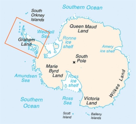
The Intergovernmental Panel on Climate Change (IPCC) estimates that the Antarctic ice sheet is currently losing around 150 billion tonnes of ice per year. One of the main areas of ice loss is from the Antarctic Peninsula, shown in the red rectangle in the map below.
Map of Antarctica. Antarctic Peninsula shown in red rectangle. Creative Commons.
This loss of ice isn’t caused by melting on the surface of the ice sheet, as even summer temperatures in Antarctica tend to be below zero degrees.
Instead, loss of Antarctic ice is largely caused by warm water at the coast melting the edges of the ice sheet.
But what scientists have found difficult to explain is how warm water, which is usually hundreds of metres deep in the Southern Ocean, reaches the shallower waters of the Antarctic coast in order to melt the ice sheet.
A new study, published in Nature Geoscience, shows how underwater robots are helping scientists to find the answer.
Underwater gliders
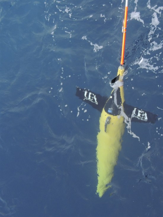
Scientists deployed three robotic underwater gliders in the Weddell Sea, near the Antarctic Peninsula. They sent them on over 750 dives of up to 1,000 metres deep, controlling them remotely from over 10,000 miles away at the University of East Anglia in Norwich.
Robotic underwater glider. Thompson et al. ( 2014)
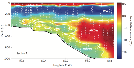
The gliders take measurements of temperature, oxygen and salinity at a range of depths. This allows the scientists to build up a profile of the temperature variations in the ocean around the Antarctic coast.
The warm water of the deep ocean is shown as reds and oranges on the right-hand side of the cross-section below. You can see the warmer water stretching out as yellow and orange blobs of heat towards the shallower water on the coast to the left.
Their results showed that this warm salty water is being transported towards the coast by swirling underwater currents known as ‘ eddies‘.
Temperature profile along a cross-section in the northwestern Weddell Sea on the coast of the Antarctic Peninsula. The shallower, coastal waters are on the left, and the deeper ocean on the right. The white section shows the seabed, part of the Antarctic land mass. The white dotted lines show the paths of the robot gliders when taking readings. Thompson et al. ( 2014)
Losing mass
Understanding how the ice sheet is melting is important for scientists to make projections of what effect it will have on global sea levels.
As co-author, Professor Karen Heywood, says in the press release:
“Our research reveals the process by which warm water is being transported towards the ice. It is important because the rapidly melting ice sheets on the coast of West Antarctica are a potential major contributor to rising ocean levels worldwide.”
In its recent synthesis report, the IPCC says there is “high confidence” that the Antarctic ice sheet has been losing mass over the past two decades. It also says that it is “likely” that the loss of ice has sped up in the last decade.
While changes in the Antarctic ice sheet are only projected to contribute around 5cm to sea levels by the end of the century, the IPCC says that it could contribute “several tenths of a metre” if ice loss accelerates.
The researchers hope that their robot gliders will help them make further advances in understanding what is happening in the Antarctic. As Prof Heywood puts it:
“The results have identified ocean features that could not feasibly have been studied by any other means. The use of ocean gliders is beginning to revolutionise our understanding of polar ocean processes.”
Thompson, A.F. et al. (2014) Eddy transport as a key component of the Antarctic overturning circulation, Nature geoscience, doi:10.1038/ngeo2289
Updated at 15:45 on 11/11/14 to correct units in third-last paragraph. It previously read '5mm' rather than '5cm'


