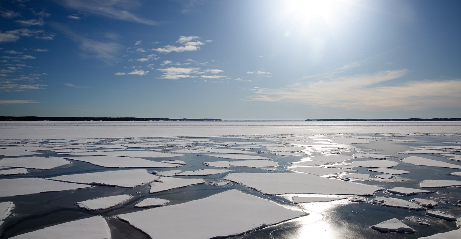
Record low volume highlights exceptional year for Arctic sea ice
Multiple Authors
12.07.16Multiple Authors
07.12.2016 | 5:24pmWith the latest sea ice data for November just in, 2016 continues to be a dramatic year in the Arctic. Following an unusually warm start to the year and record low ice in several months, a markedly sluggish freeze-up season in the back end of the year is also seeing records tumble.
Earlier this week, scientists confirmed the area of Arctic Ocean covered by sea ice – known as sea ice extent – reached a record low in November. Now, figures from the Piomas (Pan-Arctic Ice Ocean Modeling and Assimilation System) confirm the volume of sea ice also hit record lows.
At close to 8,000 cubic kilometres (cubic km), total sea ice volume in November stood at just 48% of the long-term average and the smallest of any November in the satellite record stretching back to 1979.
Taken together, these findings show little sign of recovery after an exceptionally poor start to the winter freeze-up season. This doesn’t bode well for survival of the ice through next year’s summer melting season, say scientists.
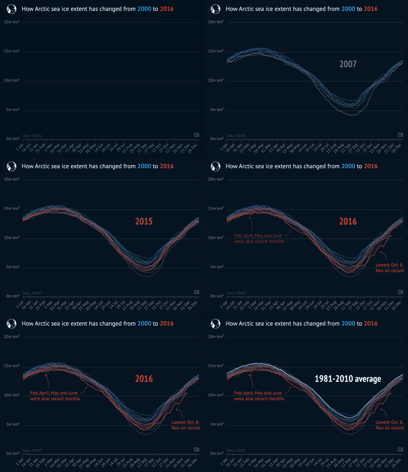
Animation: How Arctic sea ice extent has changed from 2000 to 2016. Data up until 5/12/2016, from the NSIDC.
The story so far
Sea ice is a feature of Earth’s northern and southern extremities. Being at opposite ends of the planet, Arctic sea ice hits its lowest extent around mid-September while Antarctic sea ice reaches its highest point for the year.
In 2016, Arctic sea ice clocked the second smallest winter maximum on record, after a colder than normal summer kept sea ice fractionally above the previous record set in 2012.
After the September low, ice began to build up again in the Arctic; rapidly at first, compared to other years, then slowing during October and November as the region experienced a spell of exceptionally high temperatures. Some places were up to 20C warmer than usual for the time of year, prompting a flurry of media coverage. Sea ice extent even stopped growing and started shrinking in the Barents Sea for a brief period in November, an occurrence NSIDC described an “almost unprecedented” in the satellite record.
You can see how Arctic sea ice extent in 2016 (blue line) stacks up against other years in the chart below. November 2016 averaged out at 9.1m square kilometres (sq km), 800,000 sq km smaller than the previous record set in 2006 and smaller than in 2012 (purple line), which holds the record for the lowest summer minimum in September.
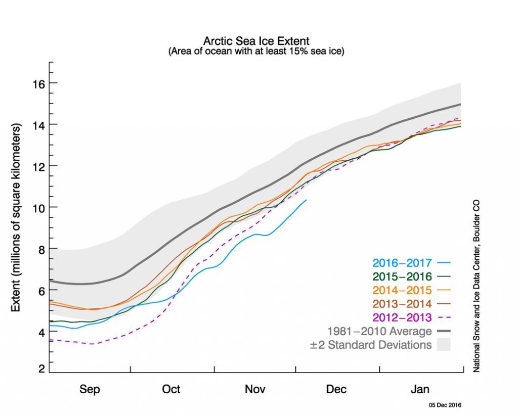
CAPTION: Arctic sea ice extent as of 5 December 2016 (blue line) compared with other years, including the record low in 2012-13 (purple). The grey line shows the 1981-2010 average, with the shaded area indicating two standard deviations either side. Credit: NSIDC
As of 5 December, Arctic sea ice extent has broken records on 52% of days this year, says Zack Labe, a PhD student at the University of California. This makes 2016 the first year to experience record low sea ice over most of the year. You can see this in the chart below, which compares daily sea ice extent in 2016 to the previous record for the same day. Where the line is above zero (blue) the 2016 extent isn’t record-breaking. Where the line drops below zero (red), 2016 set a new record.
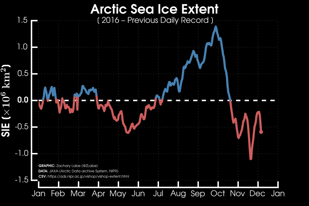
Chart showing daily Arctic sea ice data in 2016 compared to the previous record for each day. Where the line is blue, 2016 was not a record low extent, and where the line is red, it was. Credit: Zack Labe
Note that Labe’s figures use the JAXA sea ice dataset, which is collected by the Japan Aerospace Exploration Agency. Using the NSIDC dataset of sea ice extent puts the percentage of record-breaking days in 2016 slightly lower, at 45%.
Earlier this month, Labe triggered a flurry of activity on social media after tweeting the graph below. The red line shows how record lows in both Arctic and Antarctic sea ice area in October and November combined in a startling departure from previous years.
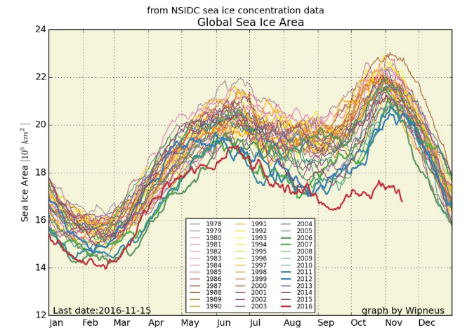
Global sea ice area over the year, combining NSIDC Arctic and Antarctic sea ice concentration data. Red line represents 2016. Credit: Zack Labe.
Record low volume
How much ocean is covered by Arctic sea ice is only part of the story. The other important factor is how thick the ice is and, by extension, its volume.
According to the latest Piomas data, a combination of the smallest sea ice extent and the second-thinnest ice cover on record puts total volume of sea ice in November 2016 at a record low for this time of year. Average sea ice volume in November was 7,880 cubic km, beating the previous record of 8,276 cubic km, set in November 2012. You can see how Arctic sea ice volume has declined through the satellite record in the chart below.
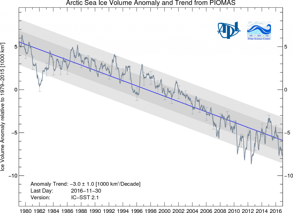
Daily Arctic sea ice volume (relative to the 1979-2015 average) for the satellite record. The blue line shows the trend during the record of a decline of 3,000km3 per decade. Credit: Piomas.
Making predictions
With both sea ice extent and volume at their smallest for this time of year, what does this mean for its prospects over this winter and into next year?
It’s more than likely the annual sea ice maximum in around March next year will be below average, says Dr James Screen, senior lecturer in the College of Engineering, Mathematics and Physical Sciences at the University of Exeter. While a new record low looks very possible, it is by no means guaranteed, he tells Carbon Brief:
“If we have a cold snap between now and then there is nothing to say that sea ice conditions couldn’t recover back towards their typical [long-term average] values.”
Different parts of the Arctic tell vastly different stories. While ice has refrozen in Baffin Bay and the Beaufort, Chukchi and East Siberian Seas, warm Atlantic water circulating onto the Arctic continental shelf seas is keeping ice in the Kara Sea and Barents abnormally low. When the Kara Sea eventually freezes up, we could see a lot of ice form very rapidly, say scientists. But there’s a long way to go if 2016’s sea ice extent is to “recover” even to 2012’s record low, let alone the long-term average for the remaining winter months.
With the freeze season already substantially delayed, there will be knock-on effects for next year’s melt season, notes Prof Julienne Stroeve, professor of polar observation and modelling at University College London and senior research scientist at the NSIDC. She tells Carbon Brief:
“Obviously, the later you freeze up the ice, the thinner it will be the coming summer, so having a late freeze-up will precondition the ice for earlier melting.”
With weather and sea ice patterns from season-to-season and year-to-year notoriously difficult to predict, scientists are stopping short of predicting a new Arctic sea ice low in 2017. But there’s no mistaking the long-term direction of travel, says Screen. He tells Carbon Brief:
“What is patently clear is that on the longer timescales we are losing ice in all months of the year and this in itself makes the chances of record lows more likely than otherwise.”

