Robert McSweeney
11.11.2014 | 4:26pmThis week the Met Office published its three-month outlook, giving a glimpse of likely weather for this coming winter. The forecast says predictions “favour” near-or above-average rainfall between now and the end of January.
This might not sound like good news for those affected by last year’s wettest winter on record, which saw the Environment Agency issue 14 severe flood warnings and evacuate 1,000 homes in the Thames catchment alone.
But a crumb of comfort might be that scientists are working on a way to predict the heavy rainfall that can cause flooding further in advance. A new study says that forecasting of heavy rain and storms could be happen as much as three days earlier by tracking water vapour instead than rainfall.
Flood forecasting
The study, published in Nature Communications, suggests that examining water vapour provides a more reliable way of predicting flood events than rainfall. The researchers use the example of the widespread flooding in Europe last winter to test their theory.
The UK has a range of organisations that track flood risk. In England and Wales, responsibility for flood risk information for the government and emergency services falls to the Flood Forecasting Centre (FFC). It was established in 2009 following the Pitt Review of the summer floods of 2007, and is jointly managed by the Met Office and the Environment Agency. These bodies are likely to be interested in how this new work could improve their own forecasting methods.
Water vapour
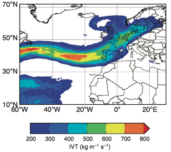
Water vapour can get transported around in the form of giant atmospheric rivers, like the one shown in the figure below.
Water vapour transport across the Atlantic Ocean in December 2013. Lavers et al. (2014)
These flows of water vapour tend to bring areas of low pressure as they travel across the North Atlantic Ocean towards Europe, and some of the vapour will eventually fall as heavy rain.
Because these flows operate on a longer timescale than the day-to-day variation of rain, streams of water vapour approaching the UK can be tracked more reliably.
Overall, the study suggests that using water vapour could allow scientists to predict heavy rain three days earlier for much of Europe, including the UK.
A dark and stormy night
The researchers tested their approach by assessing the heavy rain and flooding across Europe in last year’s winter.
Researchers analysed how early they would have been able to predict the intense storm that hit Europe on Christmas Eve last year. In the UK that storm disrupted the Christmas travel plans of thousands of people, and left 75,000 people without electricity.
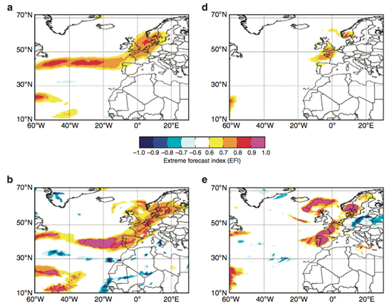
The maps below show warnings of extreme weather calculated using two different methods – water vapour transport and rainfall. Forecasts of the storm are shown for seven days before Christmas Eve (top) and one day before (bottom). Forecasts using water vapour are on the left, and those using rainfall are on the right.
Maps showing 7-day (a and d) and 1-day (b and e) forecasts of an intense storm hitting Europe on 24th December 2013. Forecasts are made using water vapour transport (a and b) and rainfall (d and e). Lavers et al. (2014)
The scientists found a stronger predictor of extreme weather using the water vapour method, shown as the orange and pink band as the storm travels across the Atlantic Ocean. In this instance, the researchers say, this is equivalent to receiving a warning two days earlier than when using rainfall to make the forecast.
The researchers argue that looking at water vapour instead of rainfall is a more reliable way of predicting heavy rainfall events, and can provide a better way of forecasting floods in Europe.
With the Intergovernmental Panel on Climate Change reporting that extreme precipitation over most mid-latitude areas are very likely to become more intense under climate change, any improvement in our ability to forecast heavy rain is likely to be welcomed both by those experiencing floods, and those responding to them.
Updated - To bring the language around the Met Office forecast in line with the forecast itself - replaced 'expects' with 'predictions favour'. Lavers, D.A. et al. (2014) Extending medium-range predictability of extreme hydrological events in Europe, Nature Communications, 5:5382 doi:10.1038/ncomms6382 [this journal is open access, therefore this article is free to download]


