Arctic sea ice could ‘shrink to record low’ this summer, say scientists
Robert McSweeney
04.21.16Robert McSweeney
21.04.2016 | 3:06pmArctic sea ice could set a new record low extent this summer, say scientists at this year’s European Geosciences Union (EGU) conference in Vienna.
Measurements from satellites and “snow buoys” deployed on sea ice reveal a “certain likeness” between recent conditions in the Arctic and those seen in the run up to the record summer low in 2012.
Carbon Brief asked other scientists here at EGU about the likelihood of this year’s summer low setting a new record.
Record low
The past winter has been something of a record-breaker for the Arctic.
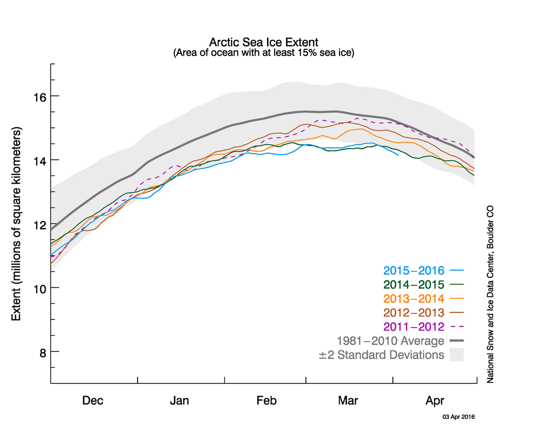
Unusually warm air temperatures during the winter restricted sea ice growth and saw 2016 bring new record lows for sea ice extent for the months of January and February. This culminated in a winter maximum extent in March that clocked in as the smallest since satellite records began in 1979.

Daily Arctic sea ice extent up to 3 April 2016 (blue) alongside daily extent for the winters of 2014/2015 (green), 2013/2014 (orange), 2012/2013 (brown) and 2011/2012 (purple). Dark grey line is the 1981-2010 average is in dark grey. Source: NSIDC
The passing of the winter peak signals the start of the melt season, where sea ice diminishes as temperatures rise through spring and into summer. Sea ice hits its lowest extent sometime in September or October. The record low for the summer minimum currently stands at 3.41m square kilometres, from 2012.
Speaking to Carbon Brief at EGU, Dr Marcel Nicolaus, a sea ice physicist at the Alfred Wegener Institute for Polar and Marine Research, says the 2016 summer could equal, or surpass, this record.
Sea ice conditions over the recent months are similar to those seen before the 2012 record, Nicolaus says. He identifies three main reasons why this year’s summer minimum could rival 2012:
These reasons won’t guarantee a new record, Nicolaus adds, because sea ice melt also depends on the warmth and storminess of spring and summer – but they do boost the odds.
Warmer than normal
With almost 13,000 scientists at the EGU conference this week, Carbon Brief caught up with a few of them to ask about the prospects for Arctic sea ice for this year and beyond.
Prof Julienne Stroeve, professor of polar observation and modelling at University College London and senior research scientist at the National Snow and Ice Data Centre (NSIDC), points out that a small winter sea ice extent doesn’t necessarily translate into a summer low.
She tells Carbon Brief:
That’s because the extent to how much sea ice melts through the summer is also dependent on the weather, Stroeve says. Thinner ice is more susceptible to being broken up by storms, which means it can melt more quickly. But scientists can’t predict the weather several months in advance, so there’s still a lot of uncertainties about how sea ice will fare over the summer.
That said, Stroeve also thinks the conditions are ripe for a new record:
Dr Ed Hawkins, associate professor at the University of Reading and lead investigator on an Arctic predictability project, makes a similar point. He tells Carbon Brief:
Even if this summer doesn’t break the 2012 record, it’s only a matter of time before it does get broken, says Dr Alexandra Jahn, assistant professor at the Institute of Arctic and Alpine Research at the University of Colorado. She tells Carbon Brief:

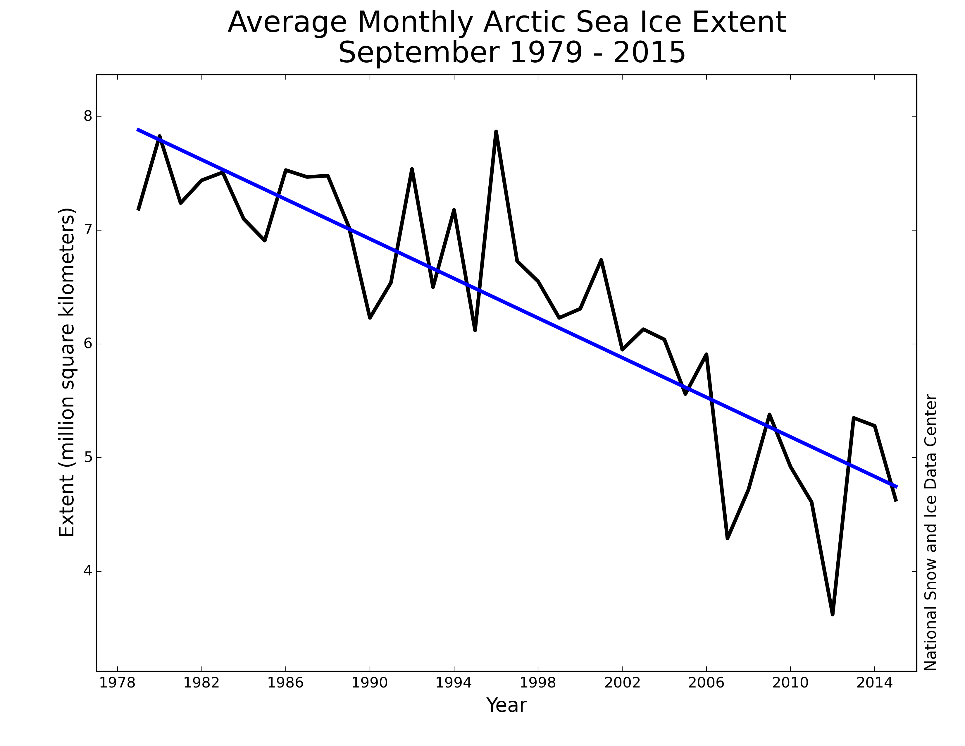
Average September Arctic sea ice extent, from 1979 to 2015. Source: NSIDC
For readers at EGU this week, there are posters on sea ice research on display this evening (5:30-7pm) in Hall X3, and talks on polar climate predictability from Hawkins, Jahn and others from 8:30am tomorrow morning in Room G2.


