
Analysis: How UK winters are getting warmer and wetter
Ayesha Tandon
02.16.24The average UK winter has become around 1C warmer and 15% wetter over the past century, new Carbon Brief analysis shows.
The analysis covers more than 100 years of data on temperature, rainfall, wind speed and snow, to assess how UK winters have changed.
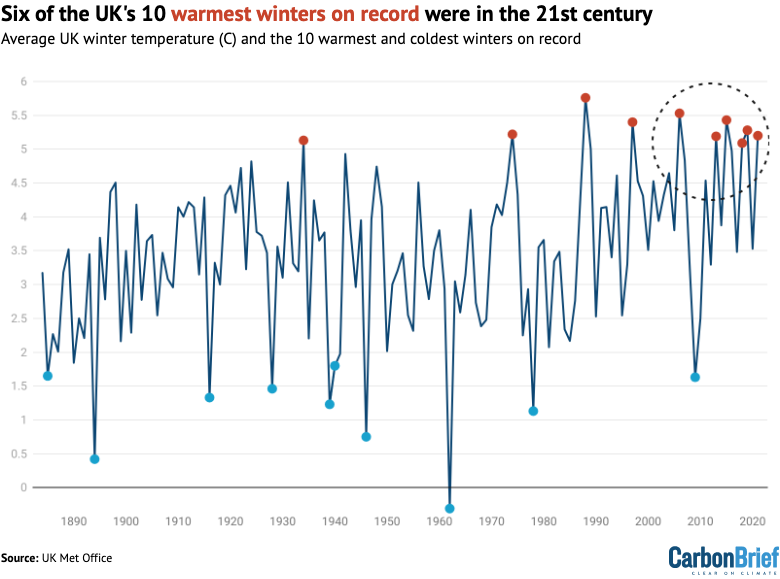
The data show that extremely warm and wet winters are becoming more common. Six of the 10 warmest winters on record were in the 21st century, and four of these also rank in the top 10 wettest years on record.
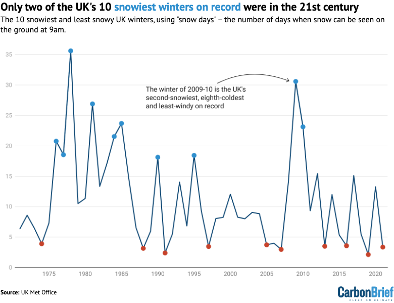
Despite the trend towards milder conditions, extreme cold snaps still hit the UK. The winter of 2009-10, for example, was dubbed the “Big Freeze of 2010” and clocked in as the UK’s least-windy, second-snowiest and eighth-coldest winter on record.
However, extreme cold periods are becoming less common. On average, the UK saw more than 12 snow days each winter in 1971-2000. This dropped to 9.5 snow days each winter by 1991-2020.
As the climate continues to warm, the UK can expect winters to continue getting warmer and wetter. Met Office projections suggest that, under an emissions pathway in line with current global policies, the average UK winter by 2080-99 will be 2C warmer and 11% wetter than they were in 1981-2000.
Warmer winters
The UK Met Office has been collecting meteorological data from thousands of weather stations across the UK since the 1880s. Using this data, it has produced a gridded dataset called HadUK, which provides complete coverage across the UK for a range of climate variables – including rainfall, temperature, snow days and wind speed – on a one-square-kilometre grid.
Carbon Brief has analysed the data for meteorological winters – defined as December, January and February – to determine how weather conditions have changed since records began.
The plot below shows a timeseries of annual winter average temperature (dark blue) over 1884-2021. These are shown as anomalies – that is, the difference compared to a baseline, which in this case is the average winter temperature over 1991-2020.
(Winters are shown on graphs in this article according to the year in which December falls. For example, the winter of December 2021 to February 2022 is shown as 2021.)
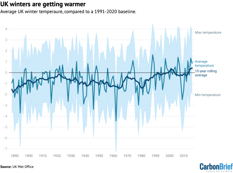
The Met Office, in line with the World Meteorological Organisation, uses 30-year averages to assess changes in UK climate. The table below shows average absolute UK winter temperatures for overlapping 30-year time periods across the full data record.
| Time period | Average temperature | Maximum temperature | Minimum temperature |
|---|---|---|---|
| 1881-1910 | 2.96* | 5.77* | 0.18* |
| 1891-1920 | 3.29 | 6.06 | 0.53 |
| 1901-1930 | 3.50 | 6.21 | 0.80 |
| 1911-1940 | 3.51 | 6.21 | 0.83 |
| 1921-1950 | 3.41 | 6.12 | 0.73 |
| 1931-1960 | 3.29 | 6.05 | 0.56 |
| 1941-1970 | 3.09 | 5.84 | 0.35 |
| 1951-1980 | 3.17 | 5.91 | 0.46 |
| 1961-1990 | 3.22 | 5.94 | 0.51 |
| 1971-2000 | 3.65 | 6.40 | 0.91 |
| 1981-2010 | 3.75 | 6.58 | 0.94 |
| 1991-2020 | 4.12 | 6.97 | 1.28 |
The average UK winter in 1991-2020 was 0.9C warmer than during 1961-90. The most recent 30-year period also includes the warmest maximum, minimum and average temperatures since Met Office records began.
In addition, with an average winter temperature of 4.64C, the most-recent decade (2013-22) – not shown in the table – has seen a further temperature increase of 0.52C above the 1991-2020 average.
Warmer winters are already impacting UK wildlife. For example, Grahame Madge – senior press officer for the Met Office – told the Guardian that animals including hedgehogs, bats and butterflies are emerging from hibernation too early:
“Abnormal warm spells during winter can encourage species out of hibernation. Butterflies such as red admirals and small tortoiseshells and other insects can be particularly challenged as they can emerge largely without access to life-saving food sources like nectar. If the warm spell is followed by a return to colder conditions, the hibernating individuals will have used up valuable energy reserves without being able to replace them, possibly with disastrous consequences.”
Meanwhile, the National Trust says warmer winters have “particularly devastating impacts for trees”, as cold snaps are often not long enough to kill off harmful diseases and pests.
Looking at individual years gives a more detailed picture. The graphic below shows the warmest and coldest 10 winters in the UK since 1884. The dark blue line shows average UK winter temperature, and red and blue dots indicate the warmest and coldest individual winters, respectively. The table below shows the dates and temperatures of these winters.
| Warmest winters | Coldest winters | |||
|---|---|---|---|---|
| Years | Temperature (C) | Years | Temperature (C) | |
| 1 | 1988-99 | 5.76 | 1962-63 | -0.31 |
| 2 | 2006-07 | 5.53 | 1894-95 | 0.42 |
| 3 | 2015-16 | 5.43 | 1946-47 | 0.75 |
| 4 | 1997-98 | 5.40 | 1978-79 | 1.13 |
| 5 | 2019-20 | 5.28 | 1939-4 | 1.23 |
| 6 | 1974-75 | 5.22 | 1916-17 | 1.33 |
| 7 | 2021-22 | 5.20 | 1928-29 | 1.46 |
| 8 | 2013-14 | 5.19 | 2009-10 | 1.63 |
| 9 | 1934-35 | 5.13 | 1885-8 | 1.65 |
| 10 | 2018-19 | 5.09 | 1940-41 | 1.80 |
The graph shows that six of the 10 warmest winters on record have occurred in the 21st century. Conversely, only one of the UK’s coldest 10 winters were in the 21st century – the winter of 2009-10.
The Met Office also provides country-level data for different parts of the UK. The plot below shows 10-year rolling average winter temperature for England (dark blue), Scotland (red), Northern Ireland (light blue) and Wales (yellow).
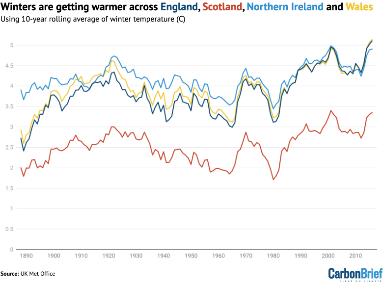
The plot shows that Scotland consistently sees the coldest winters, while England, Wales and Northern Ireland experience winter temperatures that are an average of around 1.5-2C warmer.
Snow days
As average temperatures rise across the UK, extremely cold days are becoming less common, while record-breaking warm days are becoming more frequent.
Five of the top 10 warmest days ever recorded during UK winters occurred during a single week February 2019.
Carbon Brief analysed the warmest maximum and coldest minimum temperature on record for each UK winter. The table below shows the years with the warmest (red) maximum daily temperatures and coldest (blue) minimum daily temperatures since 1960.
| Warmest maximum temperatures | Coldest minimum temperatures | |||
|---|---|---|---|---|
| Temperature (C) | Year | Temperature (C) | Year | |
| 1 | 16.1 | 2018-19 | -10.2 | 1986-87 |
| 2 | 14.3 | 1997-98 | -10.1 | 1962-63 |
| 3 | 14.0 | 2015-16 | -10.0 | 1981-82 |
| 4 | 13.8 | 1989-90 | -9.9 | 1978-79 |
| 5 | 13.6 | 2003-04 | -9.5 | 1971-72 |
| 6 | 13.5 | 1985-86 | -9.3 | 2010-11 |
| 7 | 13.4 | 2011-12 | -9.1 | 1995-96 |
| 8 | 13.3 | 2016-17 | -8.9 | 1969-70 |
| 9 | 13.3 | 2021-22 | -8.7 | 2009-10 |
| 10 | 13.2 | 1994-95 | -8.7 | 1968-69 |
Most of the warmest winter extremes on record were in the 21st century. Meanwhile, most of the coldest extremes were in the 20th century.
One way of measuring the change in extreme cold days is to count the number of “frost days” – days with a minimum temperature below 0C – recorded throughout the winter. Another way is to count the number of “snow days”, when snow can be seen on the ground at 9am.
Dr Mark McCarthy is the head of the Met Office National Climate Information Centre, which manages the UK’s climate records. He explains that to calculate snow days, an individual looks at a “representative patch of ground” at 9am in the morning, and if at least half of it is covered in snow, then it is counted as “snowy”.
These results are averaged across hundreds or thousands of observations. This means that, for example, “an average of five days of snow might mean that half of that region had 10 days and half the region had no days”, he explains.
The plot below shows the number of frost days since 1960 (red) and snow days since 1971 (blue) over winter. The black lines show the 10-year running average.
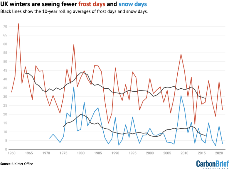
The table below shows the total number of first and snow days during UK winters for four overlapping 30-year time periods.
| Time period | Frost days | Snow days |
|---|---|---|
| 1961-1990 | 38.43 | – |
| 1971-2000 | 35.07 | 12.29 |
| 1981-2010 | 35.17 | 11.73 |
| 1991-2020 | 32.75 | 9.54 |
The plot shows that air frost and snow days are closely linked. Snow will generally not form if the ground temperature is above 5C, and in the UK, the heaviest snowfalls tend to occur when the air temperature is between 0C and 2C.
On average, the UK saw 12.3 snow days each winter over 1971-2000. This dropped to 9.5 snow days each winter by 1991-2020.
There is also regional variation in snow days. Over the entire 1971-2020 dataset, Scotland received 18.6 days of snow per winter on average, while the UK, Northern Ireland and Wales received between 7.2 and 8.8.
“Significant and widespread lying snow might have been considered fairly typical for a UK winter of several decades ago,” says the Met Office’s latest State of the UK climate report. However, it adds that “this type of event has become increasingly unusual in a warming climate over the last two or three decades”.
The graph below shows the UK winters with the greatest (light blue dots) and smallest (red dots) number of snow days since 1971.
| Snowiest winters | Least snowy winters | |||
|---|---|---|---|---|
| Years | Snow days | Years | Snow days | |
| 1 | 1978-79 | 35.62 | 2019-20 | 2.12 |
| 2 | 2009-10 | 30.59 | 1991-92 | 2.39 |
| 3 | 1981-82 | 26.90 | 2007-08 | 2.97 |
| 4 | 1985-86 | 23.69 | 1988-89 | 3.15 |
| 5 | 2010-11 | 23.13 | 2021-22 | 3.35 |
| 6 | 1984-85 | 21.54 | 1997-98 | 3.45 |
| 7 | 1976-77 | 20.77 | 2013-14 | 3.49 |
| 8 | 1977-78 | 18.54 | 2016-17 | 3.57 |
| 9 | 1995-96 | 18.43 | 2005-06 | 3.72 |
| 10 | 1990-91 | 18.13 | 1974-75 | 3.90 |
While the climate is becoming milder and snow is becoming less common, very cold and snowy winters can still happen. For example, the winter of 2009-10, dubbed the “Big Freeze of 2010” in parts of the UK media, was the least-windy, second-snowiest and eighth-coldest winter on record in the UK.
Severe snowfall that winter caused “very significant disruption across the UK”, according to the UK Met Office, which adds that “transport was particularly badly affected with snowfalls causing numerous road closures, and train and flight cancellations”.
On 18 December 2009, five Eurostar trains got stuck in the Channel Tunnel after cold temperatures caused electrical failures, trapping 2,000 people for 16 hours. All Eurostar services were cancelled for the next three days.
In January that winter, BBC News reported that “heavy snow and freezing temperatures has caused chaos across Scotland over the past three weeks, with hundreds of schools closed and motorists facing hazardous conditions on the roads”.
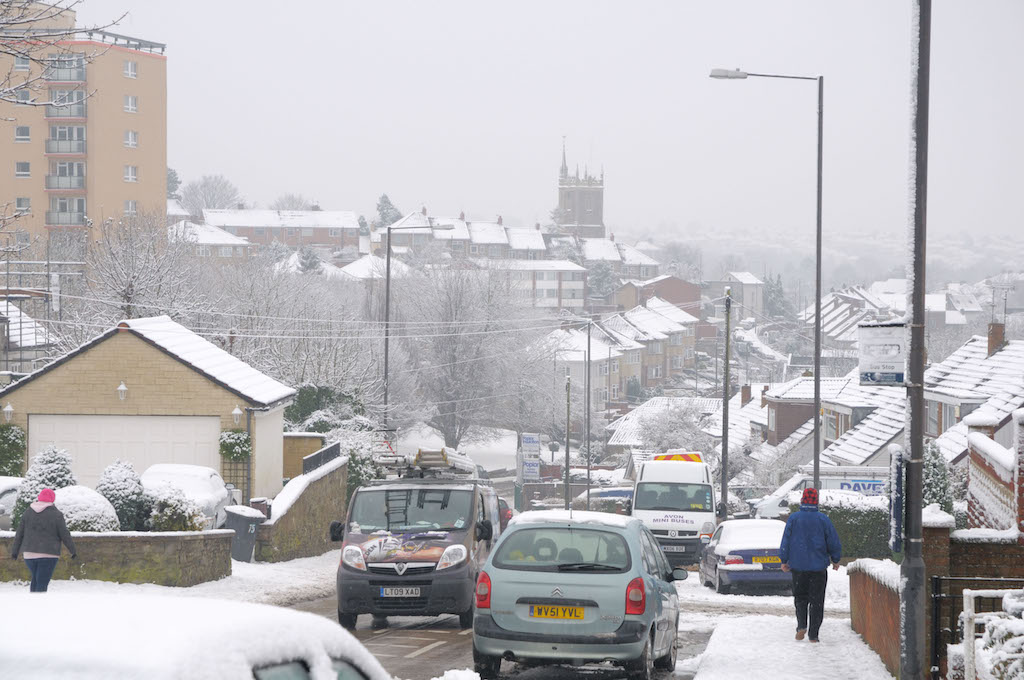
Research from the UK Met Office indicates that the odds of the UK having a winter as cold as the one in 2009-10 will drop to less than 1% by the end of the century as global temperatures continue to rise.
Wetter winters
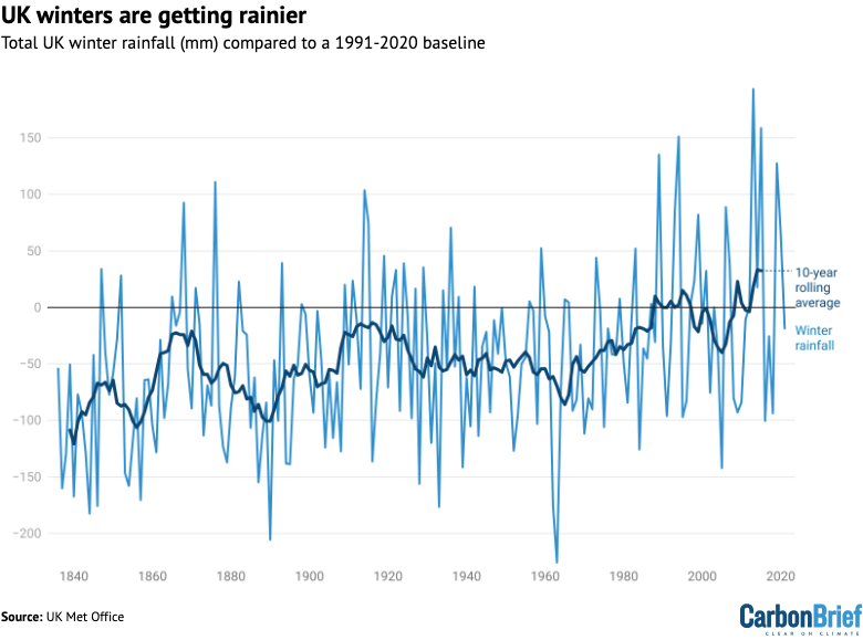
The total volume of rainfall recorded during UK winters is also rising. The plot below shows total winter rainfall in mm over 1836-2021 (blue) and the 10-year rolling average (black).
The table below shows average UK winter rainfall totals for a series of overlapping 30-year time periods across the full data record.
| 30-year period | Average annual winter rainfall (mm) |
|---|---|
| 1831-1860 | 254.69* |
| 1841-1870 | 276.00 |
| 1851-1880 | 284.28 |
| 1861-1890 | 287.46 |
| 1871-1900 | 281.51 |
| 1881-1910 | 279.06 |
| 1891-1920 | 300.55 |
| 1901-1930 | 311.07 |
| 1911-1940 | 314.51 |
| 1921-1950 | 305.00 |
| 1931-1960 | 298.76 |
| 1941-1970 | 290.82 |
| 1951-1980 | 293.23 |
| 1961-1990 | 301.82 |
| 1971-2000 | 329.22 |
| 1981-2010 | 330.01 |
| 1991-2020 | 346.98 |
Between 1961-90 and 1990-2020, the UK winters became 15% wetter on average – increasing from around 300mm of rainfall to almost 350mm. The more recent decade of 2012-21 – not shown in the table – has seen further increases, with average winter rainfall of 380mm.
The Met Office also provides country-level rainfall data. The plot below shows 10-year rolling average winter temperature for England (dark blue), Scotland (red), Northern Ireland (light blue) and Wales (yellow).
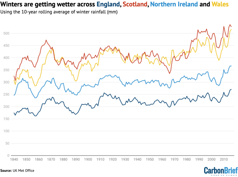
The graph shows that rainfall is increasing across all four regions of the UK, but remains consistently the lowest in England and the highest in Scotland and Wales.
Looking at the wettest and driest years across the UK shows that individual rainfall extremes are becoming more common. In a ranking going back to 1884, seven of the driest years were in the 19th century, while three were in the 20th. None of the driest years on record have been in the 21st century.
Meanwhile, four of the rainiest winters have been in the 21st century. The graph below shows the wettest (blue dots) and driest (red dots) winters since 1884.
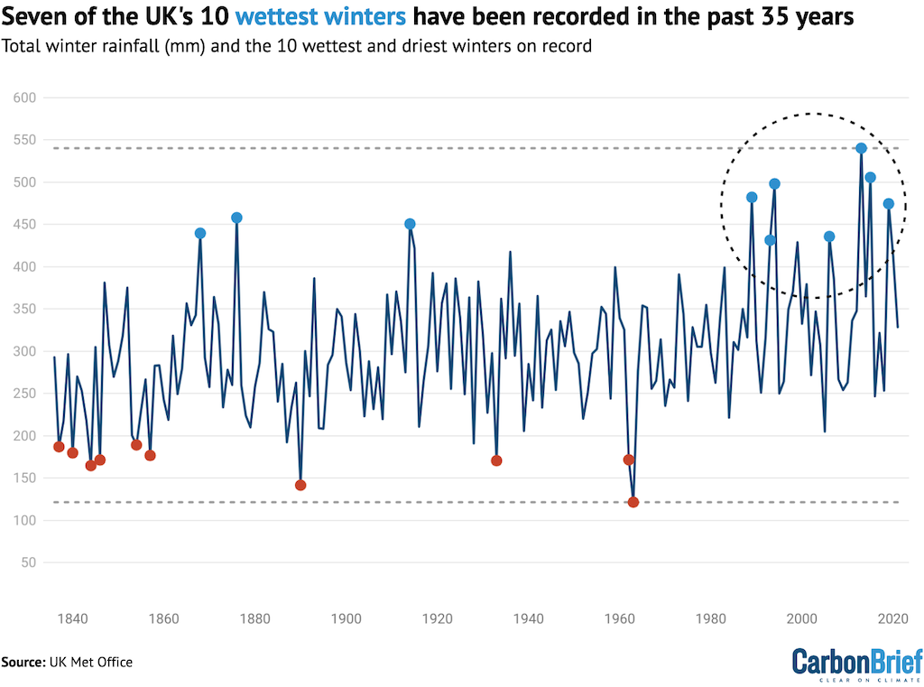
| Rainiest winters (mm) | Least rainy winters (mm) | |||
|---|---|---|---|---|
| Years | Winter rainfall | Years | Winter rainfall | |
| 1 | 2013-14 | 540.3 | 1963-64 | 121.3 |
| 2 | 2015-16 | 505.7 | 1890-91 | 141.4 |
| 3 | 1994-95 | 498.2 | 1844-45 | 164.6 |
| 4 | 1989-90 | 482.2 | 1933-34 | 170.4 |
| 5 | 2019-20 | 474.5 | 1846-47 | 171.3 |
| 6 | 1876-77 | 458.0 | 1962-63 | 171.5 |
| 7 | 1914-15 | 450.7 | 1857-58 | 176.6 |
| 8 | 1868-69 | 439.6 | 1840-41 | 179.6 |
| 9 | 2006-07 | 435.8 | 1937-38 | 186.9 |
| 10 | 1993-94 | 431.4 | 1854-55 | 189.1 |
The fact that UK winters are getting wetter makes sense, McCarthy tells Carbon Brief, because as the atmosphere heats up, it is able to hold more moisture, which can then fall as rain. According to the Clausius-Clapeyron equation, the air can generally hold around 7% more moisture for every 1C of temperature rise.
However, he adds that the observed trend in UK winter rainfall is “somewhat larger than can be explained purely through the thermodynamic process”, and explains that natural variability is also very important when discussing changes in UK winter rainfall.
“We’re in a particularly wet regime at the moment,” McCarthy explains, “so we are seeing lots of winter rainfall records and wetter winters, but it’s the combination of variability and climate change”.
For example, December 2015 topped the charts as the UK’s wettest month on record, after Storm Desmond swept across the UK, bringing very heavy rainfall and gale-force winds to much of northern England, southern Scotland and Ireland. The resulting floods left many homes inundated and at least 60,000 without power.
The winter of 2015-16 was also the third warmest on record. Preliminary analysis conducted at the time suggested that the exceptional rainfall totals were 40% more likely because of rising global temperatures.
The jet stream
The graph below shows the relationship between temperature and rainfall, where warm and wet winters are shown in the top right, while cool and dry winters are in the bottom left. Darker dots indicate more recent years.
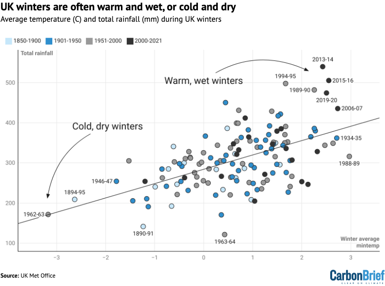
The UK’s winter weather regime is strongly linked to the strength of the jet stream. This thin, fast flowing ribbon of air in the troposphere – the lowest layer of the earth’s atmosphere – acts to steer weather systems towards the UK.
A strong jet stream brings warm and damp winds to the UK from the west, resulting in a warm and wet winter.
For example, the winter of 2023-24 has already been dominated by a series of storms. Storm Jocelyn, which swept across the UK at the end of January 2024, was the 10th named storm of the season. “The storms have mainly been driven by a powerful jet stream,” BBC News reported.
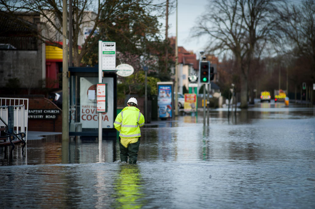
Similarly, during the winter of 2013-14, a series of storms brought record-breaking rainfall to the UK, clocking in as the wettest and eighth-warmest winter on record in the UK. Intense rainfall led to “remarkably widespread and persistent flooding”, according to the Met Office. Around 18,700 insurance claims related to flooding were filed across the UK in the aftermath of the storms, costing an estimated £451m.
One study suggests that climate change made the sustained wet and stormy weather seen around 43% more likely, and put an extra 1,000 houses at risk of flooding along the River Thames.
The study attributes about two-thirds of the increase in likelihood to the atmosphere being able to hold more moisture because the world is warming up and the remaining third to the position of the jet stream.
Conversely, a weak jet stream allows cold air from the Arctic and mainland Europe to enter from the east and north. “A slower, more buckled jet stream can cause areas of higher pressure to take charge, which typically brings less stormy weather, light winds and dry skies,” the Met Office says.
This was the case in the winter of 2009-10, which clocked in as the eighth-coldest and least-windy UK winter on record.
Sometimes, the jet stream can even get “stuck” – a phenomenon called blocking – and instead of shunting weather systems from west to east, it can allow a spell of cold, dry weather to sit over the UK for many days.
While there is a clear trend of UK winters getting warmer and wetter, the data on wind speed is less clear-cut. However, cool weather in the UK is often associated with low speeds, while warm weather is often brought by strong gusts.
The plot below shows average UK winter wind speed over 1969-2021 in knots. The darker line shows the 10-year rolling average, and the most and least windy years are shown by red and blue dots, respectively.
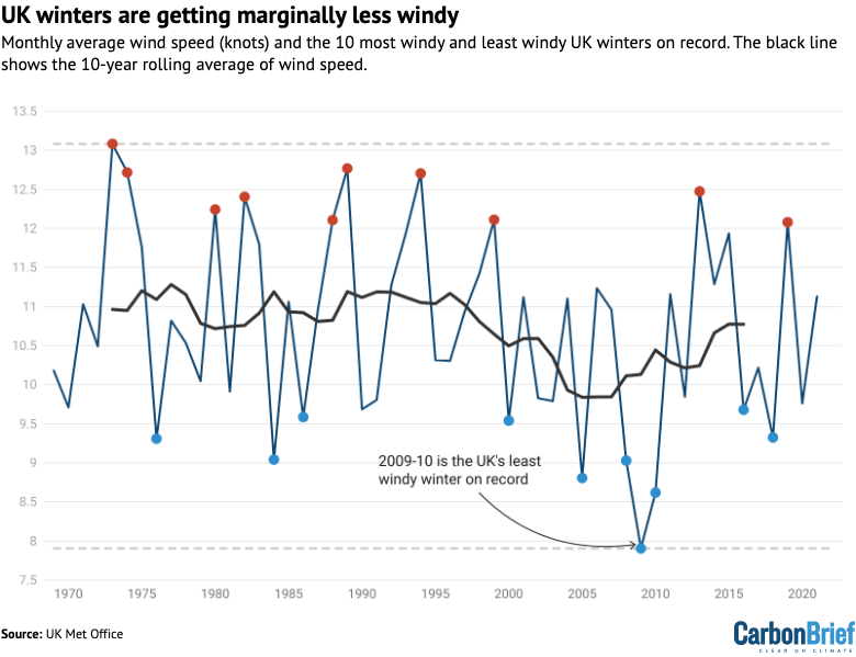
| Windiest winters | Least windy winters | |||
|---|---|---|---|---|
| Years | Average windspeed (knots) | Years | Average windspeed (knots) | |
| 1 | 1973-74 | 13.08 | 2009-10 | 7.90 |
| 2 | 1989-90 | 12.77 | 2010-11 | 8.62 |
| 3 | 1974-75 | 12.72 | 2005-06 | 8.81 |
| 4 | 1994-95 | 12.71 | 2008-09 | 9.03 |
| 5 | 2013-14 | 12.47 | 1984-85 | 9.04 |
| 6 | 1982-83 | 12.41 | 1976-77 | 9.31 |
| 7 | 1980-81 | 12.24 | 2018-19 | 9.32 |
| 8 | 1999-2000 | 12.11 | 2000-01 | 9.54 |
| 9 | 1988-89 | 12.11 | 1986-87 | 9.59 |
| 10 | 2019-20 | 12.08 | 2016-17 | 9.68 |
The table below shows average UK wind speed totals for three overlapping 30-year time periods.
| 30-year averages | Average wind speed (knots) |
|---|---|
| 1971-2000 | 11.06 |
| 1981-2010 | 10.60 |
| 1991-2020 | 10.55 |
McCarthy tells Carbon Brief that there has been a notable decline in UK wind speed when looking at annual data, which is consistent with the trend of “stilling” – a slowdown in near surface wind speeds – measured globally. However, he says that this trend is less obvious in the winter-only data.
Meanwhile, the UK State of the Climate report 2022 states that there are no compelling trends in storminess when considering maximum gust speeds over the last four decades.
A range of other atmospheric circulation patterns can also impact UK winters.
The North Atlantic Oscillation (NAO) is a large-scale atmospheric pressure see-saw in the North Atlantic region, which describes the difference in air pressure between the high pressure sitting over the Azores, to the west of Portugal, and the low pressure over Iceland.
When the NAO is “positive” and the pressure difference is stronger than usual, the jet stream shifts towards the poles, bringing mild, wet and windy weather to North American and Eurasian winters and leaving the Arctic very cold.
When it is “negative” and the pressure difference weakens, storm tracks shift towards the equator, bringing cold, dry and calm winters to Europe.
Another mechanism is the “stratospheric polar vortex”. This low-pressure weather system sits around 50km above the Arctic in the stratosphere – the layer of the atmosphere above the troposphere. Its main feature is the strong west-to-east winds which encircle the north pole. These winds are known as the “polar night jet” because they only appear during the dark Arctic winter.
As with the jet stream in the troposphere, the polar night jet forms a boundary between the very cold Arctic air and the warmer air over the mid-latitudes. However, if something disrupts the stratospheric polar vortex it can weaken, reverse direction and even split into two. This can trigger a “sudden stratospheric warming” event where air collapses in over the Arctic, causing a spike in temperatures in the stratosphere – by as much as 50C in just a couple of days.
This allows the cold air the polar vortex was holding in to spill out into the mid-latitudes during the weeks that follow. This is what caused the “Beast from the East” snowstorm that hit the UK in 2018. (This is not well reflected in the UK winter data, as the brunt of the storm hit in March 2018 after the end of meteorological winter.)
In general, however, the UK has experienced a run of mild, wet winters in the most recent decade, including the very wet winters of 2013, 2015 and 2019. These are consistent with a positive phase of the NAO and strong polar vortex, according to the latest State of the UK Climate report.
Projections
As the planet continues to warm, the UK’s climate will shift “towards warmer, wetter winters and hotter, drier summers”, the Met Office says.
The UK Climate Projections 2018 (UKCP18) is a series of climate change projections for the UK produced by the UK Met Office, taking advantage of the latest observed data and climate models
The projections include temperature and rainfall changes – for averages and extremes – for each month and season of the year, and for different emissions scenarios and future time periods throughout this century.
The maps below show the probabilistic projections for summer average temperature (top) and winter precipitation (bottom) in the 2080s under the RCP4.5 emissions pathway, relative to a 1961-90 baseline. In this pathway, global temperatures are projected to rise by around 2.7C of warming above pre-industrial levels by 2081-2100, which is broadly in line with the trajectory under current global policies.
The three percentiles (10th, 50th and 90th) reflect the likelihood of those temperatures and rainfall anomalies occurring. The 50th percentile (middle maps) is the “central estimate” across the models, while the 10th (left) and 90th (right) percentiles reflect the lowest 10% and highest 10% of the model results.
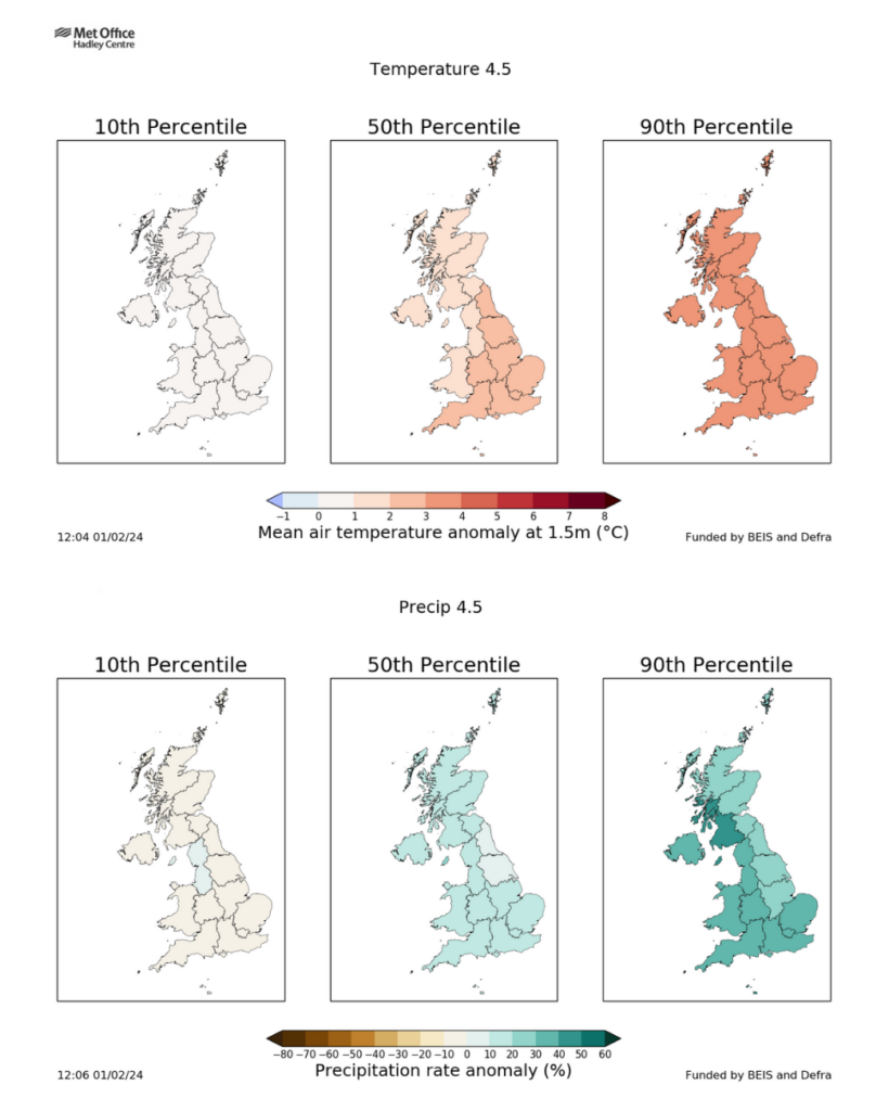
The table below shows UKCP18 projections for changes in average UK winter temperature and precipitation under RCP4.5, under the 10th, 50th and 90th percentile, for 2080-99, compared to a 1981-2000 baseline.
| 10th percentile change | 50th percentile change | 90th percentile change | |
|---|---|---|---|
| Change in average winter temperature (C) | +0.7 | +2.0 | +3.5 |
| Change in average winter precipitation (%) | -2.0 | +11.0 | +25.0 |
As a central estimate, these projections suggest that by 2080-99, UK winters will be 2C warmer and 11% wetter than they were in 1981-2000.
However, the picture is more complex for wind speed. The Met Office explains that storms in the UK are influenced by factors including sea surface temperatures, Arctic sea ice melt and the jet stream.
It says that “under climate change some of these influences will strengthen storms and others weaken them, as well as potentially change the parts of the world that storms affect”.
It adds:
“UKCP18 projected an increase in near surface wind speeds over the UK for the second half of the 21st century for the winter season when more significant impacts of wind are experienced. However, the increase in wind speeds is modest compared to natural variability from month to month and season to season, so confidence is low.”


